Day Zero: A long evening drive
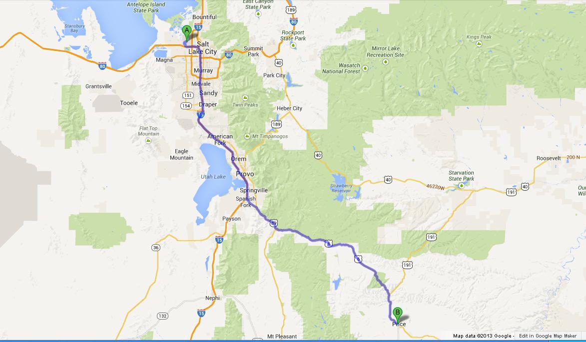 |
| Day 0 Agenda |
When we got down at SLC airport at 9:05 PM (MST), we were
just hoping that we would at least hit one of the 10 PM closing downtown restaurants for
our dinner. But a more than 30 min long
wait at the airport rental car office made us forfeit the slightest chances.
Our Day zero plan was to drive and reach Price UT , from
where we could officially flag off our road trip. The 123 mile stretch meant at
least 2 hours of drive before we take a tight sleep for the night. With a quick
stop at Winco foods and with a burger at a Drive through Burger King at Provo, we made it
to Price at around 12:30 AM.
Day One: Peeping from the Island in the Sky!
Water. This is what this trip was all about. May it be the presence of it, or the lack of it, the need for it, or the void of it and most
significantly, the ART OF IT! Never
before I had been marveled so much about this wonderful substance, even not at the
Niagara Falls!
Planning for two of the National parks on a single day might
not be the greatest of the ideas. But the fact that Canyonlands National park
and Arches National park are less than 30 miles apart tempted us to squeeze
these into a day’s schedule. This, we
decided once we chose the ‘Island in the sky’ unit of Canyonlands, over the ‘The Needles’ unit. Even though both these Units are part of Canyonlands National
park, one should keep in mind that these two units are not interconnected
through roads inside the park. This means, if you are planning to visit both
the units, then your only option is to take 2 separate exits from Highway 191
which makes the driving distance between the two units more than 70 miles!
 |
| Colorado River at Dead Horse Point Overlook |
We chose Island in the Sky mainly because of two reasons.
(a) Choosing Needles unit would add an additional
day to our plan as it is hard to cover Arches and Needles unit in a single day.
(b) Most the views points at Island in the Sky unit
are motorable where as there were considerable amount hikes to be done for grabbing some of the views at the
Needles unit.
Our first stop of the day was at Dead horse Point State
Park. Taking the exit into Route 313 at around 9 miles north of Moab UT on US
191, and then heading around 15 miles in 313 brought us near a sign post of
Deadhorse point state park. Even though our destination was the Canyonlands NP, we didn't want to miss on a State park which was just within 3-4 miles reach from our main route. We headed 3.5 miles in that road to the visitor
center.
One mile further would lead to the Deadhorse point. Stepping ahead into the viewpoint in the park, we saw the first grandeur of the trip. Towering 2000 feet above the horseshoed Colorado river, this point gives one of the spectacular views of Rock-Water combination.
There are a couple of rim trails (West and East rim trails) which heads down till the visitor center. For people heading towards island in the sky, I suggest this could be one of your surprise spot!
One mile further would lead to the Deadhorse point. Stepping ahead into the viewpoint in the park, we saw the first grandeur of the trip. Towering 2000 feet above the horseshoed Colorado river, this point gives one of the spectacular views of Rock-Water combination.
 |
| Along the East rim at Dead Horse Point |
There are a couple of rim trails (West and East rim trails) which heads down till the visitor center. For people heading towards island in the sky, I suggest this could be one of your surprise spot!
As we headed back into 313, the day turned hotter and the temperature soared to upper
90s. Car AC was the sole savior.Within next 20 minutes we were at
the gates of the Canyon lands National Park, buying the $80 National parks
permit. As we had a plan of visiting all 5 NPs of Utah, this pass probably was
the best deal. Heading a mile from the visitor center on the Island in the Sky
road, we stopped at a viewpoint to have a view of the Shafer trail below, further
5 miles drive brought us into the Y intersection of the park. As we headed
towards the Grand Point, we stopped at the Buck Canyon overlook for the first
view into the terrain.
We realized how this place stood by its name, a huge
island 1000 feet up in the sky, looking into the vast endless terrain below.
‘Mesa’ is the word used for such lands,
the one where we drove and were standing right now. I haven’t often heard that
word till then, but have heard a lot during the next 4 days. Island in the Sky
is one such massive mesa, needing a 34 mile round trip to tour the entire mesa.
Any view from the overlooks is not complete without a glance into the massive
walls of the mesa that we stood.
 |
| The Island and The Sky! at Buck Canyon Overlook |
Next, we headed towards Grand View overlook. This terrain
here is different because of the view of a distant canyon with a white patched
rim. It looks as if a giant dinosaur had landed its paw creating a massing
crater beneath. The striped carved red walls of the canyon had a white cap over
them.
Our next point was the much awaited Mesa Arch. The trail-head is close to the Y intersection of the Island Mesa. A short hike of
quarter mile took us near the arch. The first sight wasn't that great. At
once, I thought this was an over-hyped point. But next 50 steps towards the arch
proved me wrong! As I peeped through the arch, the view across it was stunning.
No wonder people choose it for a Sunrise destination.
I imagined how beautiful
it would be to see the golden rays of morning sun striking this natural stone arch framing inside it the spectacular view of just awaking La Sal Mountains, Buck Canyon and the
Monster Tower. A perfect window overlooking a perfect landscape!
 |
| Mesa Arch - Your photo doesn't need a frame! |
With the view still freshly framed in the memory, we headed
towards the other shoulder of the Y, upheaval dome. There are not much scenic
points along this 5 mile route. We drove by the whale rock and had our lunch at
one of the picnic shelters at upheaval dome.
We did not take the hike into the dome as we thought this 2 mile hike would eat up our day. We drove towards the park exit and joined 313 to our next destination - Arches National Park!
We did not take the hike into the dome as we thought this 2 mile hike would eat up our day. We drove towards the park exit and joined 313 to our next destination - Arches National Park!
 |
| Day 1 Agenda |
Hi there- My wife and I recently flew to Las Vegas and rented a car and traveled to Zion, Bryce and Arches. Do you know anything about an abandoned small stone house on the road side of Highway 24, west of Hanksville. It was surrounded by a chain link fence, was in the desert where no facilities were available for miles....just wondered what it was. Thanks
ReplyDelete